Data Science
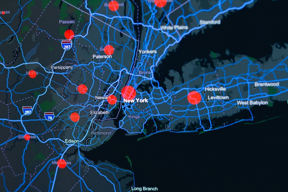
Geospatial Data Management
GIS-integrated platforms and spatial analysis services that transform location data into actionable intelligence — powering smarter decisions across Africa.
Every development challenge in Africa has a geography. Where services are missing, where populations are growing, where infrastructure is failing, where climate risk is highest the answers are hidden in spatial data. Dali Geotech Ltd was built on the conviction that location intelligence is the single most underutilised asset in African decision-making.
We collect, process, manage, and analyse geospatial data at every scale from individual plot boundaries to continental land cover classifications and we deliver it in formats that planners, engineers, policymakers, and investors can actually use. Our GIS team brings together field surveyors, remote sensing specialists, spatial database engineers, and cartographers to give you a complete geospatial capability under one roof.
We work across the full geospatial data lifecycle. That means we can acquire raw satellite imagery and drone data, orthorectify and classify it, load it into a structured geodatabase, serve it through a web map interface, and integrate it directly into your dashboards and decision-support tools all in one engagement. You do not need four separate vendors. You need Dali Geotech.
A complete suite of GIS and spatial data services from data collection in the field to analysis, visualisation, and integration into your existing systems.
Custom web-based GIS platforms built on open-source and cloud geospatial stacks giving your team interactive maps, layer management, spatial queries, and printable outputs from any browser.
Structured spatial databases with PostGIS or Esri File Geodatabase designed with correct topology, coordinate systems, feature catalogues, and metadata standards for long-term data integrity.
Satellite imagery acquisition, processing, and classification land use mapping, vegetation indices, change detection, flood extent, and crop health assessments at district to national scale.
GPS-based field surveys for boundary demarcation, infrastructure location, asset enumeration, and household mapping using mobile data collection tools with direct integration to our GIS platforms.
Advanced spatial analysis including proximity modelling, catchment delineation, network analysis, hotspot mapping, terrain analysis, and multi-criteria suitability assessments for site selection and planning.
High-quality print and digital maps for reports, donor presentations, operational briefings, and public communication designed to international cartographic standards with full branding compliance.
Our team handles every major category of geospatial data integrating multiple source types into coherent, analysis-ready datasets for your organisation.
Country, region, district, ward, and village boundaries for all African nations maintained and updated against official government gazetteers and used as the backbone for spatial disaggregation of any dataset.
Road and rail networks, utility lines, water pipelines, and telecom infrastructure captured from field surveys, OpenStreetMap, and official sources, cleaned and topologically corrected for network analysis.
Digital elevation models, slope and aspect calculations, watershed delineation, and flood risk surfaces derived from SRTM, ALOS, TanDEM-X, and drone-acquired point clouds at varying resolutions.
Classified land cover maps from Sentinel-2, Landsat, and PlanetScope imagery updated annually or seasonally to track agricultural expansion, deforestation, urban growth, and wetland change.
Digitised building footprints, settlement extents, and informal urban mapping extracted from very-high-resolution imagery used for population estimation, service planning, and risk exposure analysis.
River networks, lake boundaries, wetland extents, groundwater potential zones, and seasonal inundation mapping critical for WASH planning, irrigation design, and climate resilience assessments.
A structured, quality-assured workflow that takes you from raw location data to integrated spatial intelligence your organisation can act on.
We audit your existing spatial data, identify gaps, and define the best acquisition strategy whether that means field surveys, satellite imagery, open data, or a combination.
Raw data is cleaned, projected to the correct coordinate system, topologically validated, attributed, and loaded into a well-structured geodatabase with full metadata documentation.
We run the spatial analyses your questions demand proximity, network, suitability, change detection and visualise results as interactive maps, dashboards, or publication ready cartographic outputs.
Outputs are integrated into your platforms via WMS/WFS, API, or file delivery. We provide training and update protocols so your team can maintain and grow the spatial dataset over time.
We have delivered geospatial solutions across government, development, and private sector contexts here are some of the spatial problems we solve.
Systematic demarcation and mapping of land parcels for government land registries supporting land tenure formalisation, dispute resolution, and property tax administration.
Spatial analysis of health facility, school, and water point catchments to identify underserved populations guiding infrastructure investment and resource allocation decisions.
Geospatial data packages and spatial analysis for EIA processes mapping sensitive habitats, population exposure zones, and cumulative impact corridors for infrastructure projects.
Flood, drought, and landslide risk mapping combining terrain, climate, and socioeconomic data used by civil protection agencies and DRR programmes to prioritise preparedness investment.
Seasonal crop mapping, agro-ecological zone delineation, and remote sensing-based yield estimation to support food security early warning and input subsidy targeting.
Multi-temporal urban extent mapping, informal settlement analysis, and infrastructure gap assessments to guide city masterplanning and ward-level capital investment priorities.
We combine the best of open source GIS, commercial remote sensing tools, and cloud spatial infrastructure chosen to match your team's capacity and your project's requirements.